Detail from 1889 ‘China’ map by Rand McNally and Company (Source: Wikimedia Commons)


Research Assistant Intern
Ultimately, the current U.S. policy of deeming China’s maritime jurisdiction claims around the Paracel Islands as ‘excessive’ stems from a peerlessly strict reading of the United Nations Convention on the Law of the Sea (UNCLOS).
While a contemporary reading of the dispute suggests that the U.S. and China have always been rigidly out of step, a historical analysis of the issue shows that U.S. policy towards the Paracel Islands evolved over time from one of pragmatic ambiguity on questions of sovereignty and maritime jurisdiction to the legal purism on maritime claims that we observe today.
Before UNCLOS came into force in 1994, the U.S. showed a remarkable sensitivity to China’s sovereignty and maritime jurisdiction claims in and around the Paracel Islands. This was due to both the relatively lenient international consensus regarding maritime law prior to the passage of UNCLOS and the geopolitical exigencies of the Cold War.
Since the end of the Cold War, and especially during the Trump and Biden administrations, Washington has intensified its opposition to maritime claims which violate the provisions of UNCLOS through diplomatic protests and Freedom of Navigation Operations (FONOPs). However, the blind eye that the U.S. turns to maritime claims by India, France, Spain and others in cases similar to the Paracels calls into question the supposed apolitical nature of Washington’s challenge to ‘excessive maritime claims’ in the South China Sea.
Given the Paracel Islands’ unique nature—an outlying archipelago owned by a continental state—and unique location—at an internationally-contested crossroads of global trade—future developments regarding maritime rights and jurisdiction around the Paracels are likely to be critical to the future of international maritime law at large.
Going forward, Washington may have to pressure its allies to bring their maritime claims more in line with UNCLOS. If the U.S. can achieve this, then the legal and operational challenges posed by both individual nations and allied blocs (AUKUS, the Quad, etc.) to China’s maritime claims would be more authoritative. Simultaneously, Beijing may be able to rally support from other continental states with outlying islands (France, Ecuador, etc.) who, like China, may wish to preserve a more liberal reading of UNCLOS.
Ever since China declared a system of straight baselines around the mid-ocean Paracel Islands in 1996, the United States has considered this claim illegal on the grounds that the United Nations Convention on the Law of the Sea (UNCLOS) reserves this right only to archipelagic states. However, the history of U.S. policy towards the Paracel Islands shows a remarkable evolution from pragmatic non-interference to peerless defense of the letter of the law. While a historical approach to this case reveals nuance in what otherwise seems like an inflexible U.S. policy, its comparison with similar cases in other states ultimately casts doubt on the supposedly apolitical nature of U.S. challenges to ‘excessive maritime claims’ in the South China Sea.
The United States’ knowledge of the Paracel Islands (also known as the Xisha Qundao in Chinese and Quần đảo Hoàng Sa in Vietnamese) likely dates back to the 18th and 19th-centuries when Western mariners surveyed and mapped the South China Sea in efforts to ‘discover’ high sea lanes and plot any obstacles along the lucrative trade routes linking India to the Qing Empire. The first specific reference to the Paracels in the U.S. geo-body came in 1911, after the U.S. annexation of the Philippines, when the Navy’s Hydrographic Office reproduced a German map of the Paracel Islands and several other regional maps in an effort to ‘take stock’ of its new colony’s surroundings.
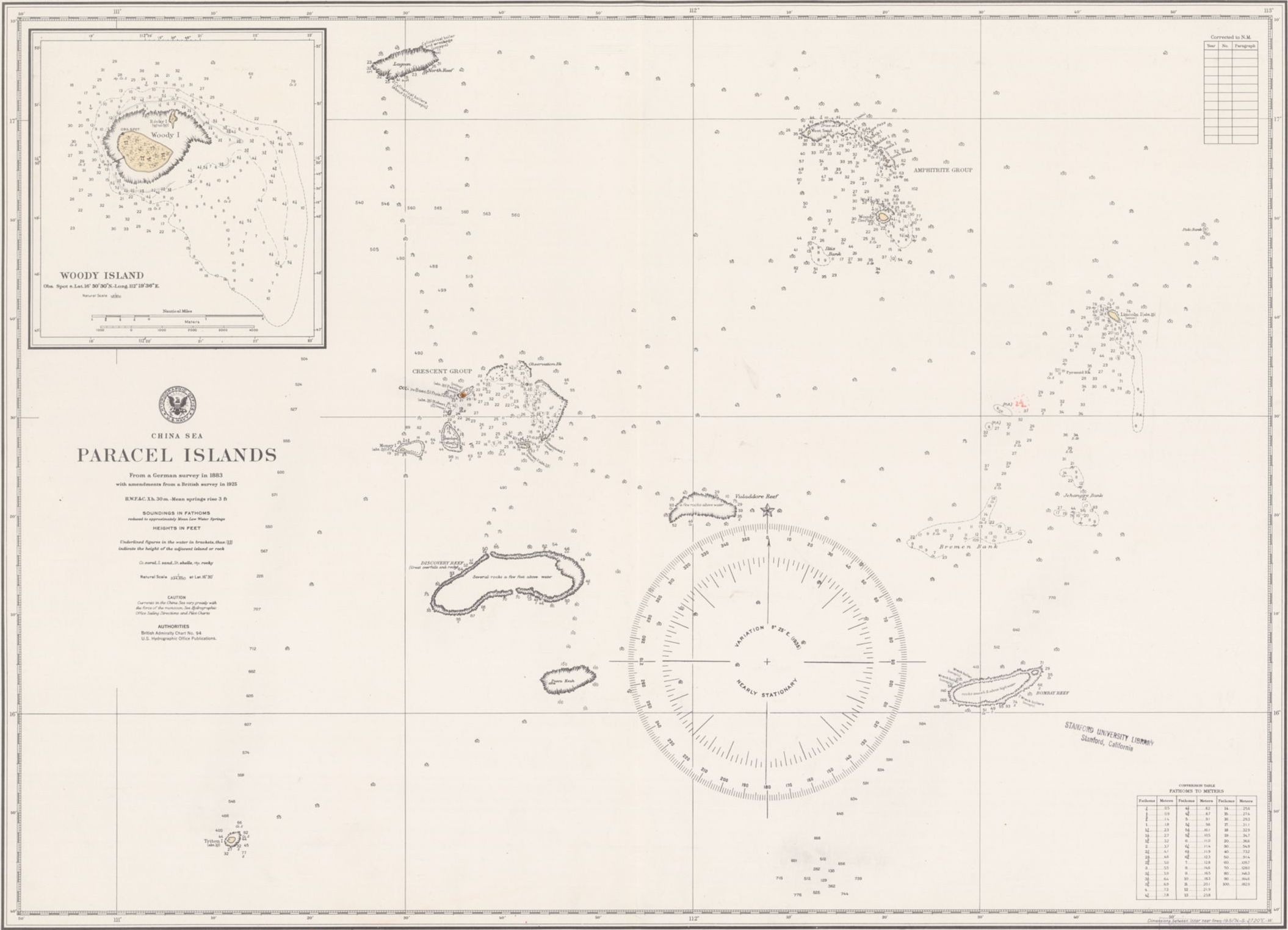
The U.S. did not view the islands of the South China Sea through a political lens until the 1930s. After the French colonial administration in Vietnam laid claim to the Paracels in 1932 and the neighboring Spratlys the following year, the Consul-General of the Republic of China in Manila approached the U.S. Coast and Geodetic Survey (USC&GS) for help in confirming the position of what China held were breaches of sovereignty. Following this episode, the Navy’s Hydrographic Office reissued its 1911 map of the Paracels with additions from a more recent British survey. This was followed in 1937 when the director of the USC&GS confirmed France’s encroachment into the Paracels in a memorandum weighing the merits of claiming the Scarborough Shoal on behalf of the Philippines.
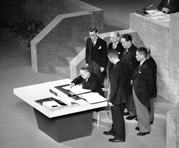
The Paracels appeared on Washington’s radar again in the 1940s as the Allied Powers negotiated the Treaty of San Francisco with Japan following the latter’s defeat in the Second World War. Article 2(f) of the final treaty states that “Japan renounces all right, title and claim to the Spratly Islands and to the Paracel Islands,” which it had seized from the French in 1939. Over the course of the war, maps and declarations were replaced by physical control as the main instrument of sovereignty over the small archipelago. Cognizant of this fact, a year after the end of hostilities in the Pacific Chinese forces set sail to reassert authority over key islands in the South China Sea—in warships gifted by the U.S.—landing on Woody Island (Yongxing Dao) in the Paracels on November 8, 1946. However, the postwar settlement remained ambiguous as to what would happen to the Paracels following Japan’s renunciation of claims. In the initial U.S. draft of the treaty made on March 19, 1947, the Paracels were explicitly named in the list of renounced Japanese claims, but notably disappeared from subsequent drafts until August 7, 1950. Around this time, a U.S. memorandum answering questions from its Australian allies about the most recent draft provides more insight into the U.S. position towards the islands of the South China Sea. Here, the U.S. clarified that the “Pratas Reef…Paracel Islands and Spratly Island[s]” should be excluded from the list of Pacific islands that would stay under U.S. occupation after the war (such as the Ryukyu and Bonin islands, since returned to Japan), and referred the status of the Paracels as “disputed between France and China.”
This apparent agnosticism as to who these islands should retrocede is regarded by some commentators as evidence that the U.S. and other signatories of the Treaty of San Francisco intentionally left questions of sovereignty in the South China Sea undetermined. However, further evidence suggests that the U.S. vacillated between taking the Paracels’ return to China for granted or neglecting the islands entirely. The wartime Cairo and Potsdam declarations confirmed, in principle, that Chinese continental and island territory seized by Japan should return to China after the war. Neither declaration, however, mentioned the Paracel or Spratly islands by name. The relative insignificance of these small archipelagos persisted throughout the negotiations of the post-war settlement.
For instance, in a memorandum on June 11, 1951, John Foster Dulles, the lead U.S. negotiator of the treaty who would later become Secretary of State, was asked by his French counterpart about “the question of two small partly submerged islands to the East of Hainan. One…occupied by 50 Chinese Communists and the other by 20 Vietnamese.” Dulles simply responded that “he was not familiar with this territorial problem.” However, when the U.S. negotiators were apprised of the Paracels issue, they seem to have assumed that it would retrocede to China as discussions swiftly moved to ensuring that only Chiang Kai-Shek’s nationalist government in Taiwan could exercise these sovereign rights on behalf of China. Just weeks after his conversation with the French, in a June 28, 1951 memorandum to Secretary of Defense George Marshall, Dulles wrote:
It should be made certain that there be no basis, either stated or implied, written into the Treaty which might provide for the possible legal claim of Communist China to sovereignty over Formosa, the Pescadores, Paracel, and Spratley [sic] Islands…as well as to accession of real property, such as consulates, buildings, and businesses, formerly held by the Government of China or its nationals in these areas. It would appear that in its present form the second sentence of Article 4 (a) might afford Communist China a valid claim over that territory were it to sign and ratify this Treaty.
The second sentence of Article 4(a) which Dulles referred to in the memorandum reads:
The property of any of the Allied Powers or its nationals in the areas referred to in Article 2 shall, in so far as this has not already been done, be returned by the administering authority in the condition in which it now exists.
While neither of the rival governments of China were invited to ratify the treaty, the U.S. was aware of the potential long-term ramifications of these provisions given the fact that Chinese nationals had, in fact, returned to the Paracels in 1946. In spite of Dulles’ concerns, the treaty drafters did not quibble over the implications of these articles to a few small archipelagos. The ‘Island Chain Strategy’ of the United States the early stages of the Cold War—which emphasized the geopolitical need to control Pacific Rim islands like the Ryukyus, Taiwan, and the Philippines—drove Washington to internally lump the Paracels in with the more critical islands that it wanted to keep under allied control, while maintaining enough public ambiguity to legally stymie Beijing’s claim to the islands if it built legitimacy as a successor to the Republic of China in the years to come.
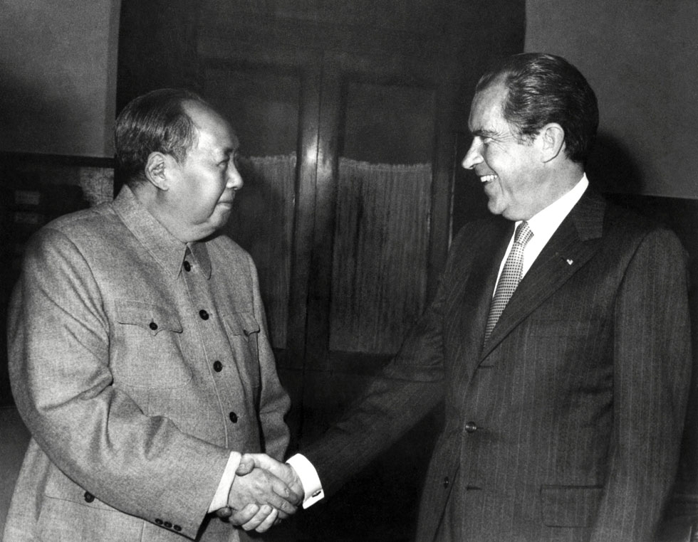
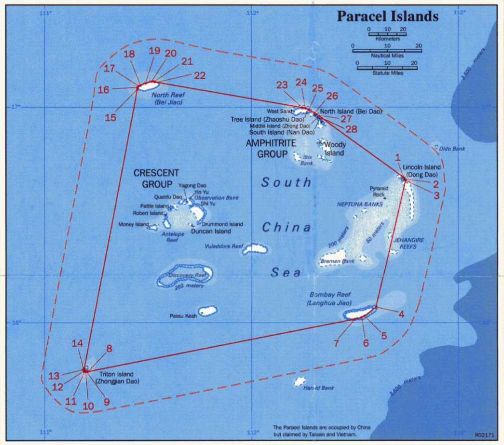
The Paracels resurface in U.S. records against the backdrop of the Nixon administration’s opening to China and the withdrawal from the Vietnam War in the early 1970s. Following Nixon’s famous trip to China in February of 1972, which ushered in unprecedented communication between the U.S. and the PRC, the U.S. apologized for an incursion by its naval vessels and aircraft “within twelve nautical miles…but [no closer] than three nautical miles…in the vicinity of Lincoln [Dong] Island in the Paracels.”
In the interest of U.S.-Chinese relations the U.S. side has issued instructions that henceforth a distance of at least twelve nautical miles should be maintained from the Paracel Islands. This is without prejudice to the U.S. positions either on the territorial sea question or the various claims to the Paracel Islands.
Message From the Government of the United States to the Government of the People’s Republic of China, Washington, April 3, 1972
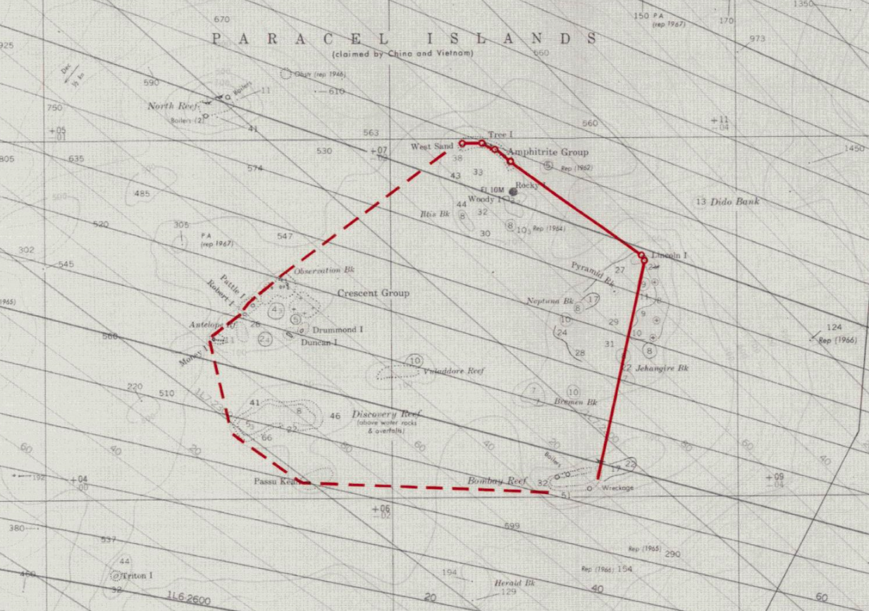
Subsequently, on July 1 the Office of the Geographer and Global Issues in the U.S. Department of State published its 43rd issue of the Limits in the Seas series (LIS-43), which contained its first formal commentary on China’s maritime policy. In this document, the U.S. analyzed China’s 1958 law that declared a 12nm territorial sea extending from baselines to be “composed of the straight lines connecting basepoints on the mainland coast and on the outermost of the coastal islands;” an arrangement which would also apply to “Taiwan and its surrounding islands, the Penghu Islands, the Tungsha Islands, and Hsisha [Paracel] Islands, the Chungsha Islands, the Nansha Islands, and all other islands belonging to China.”
Overall, the U.S. determined that “Peking appears to have taken a realistic and non-expansive attitude in drafting its straight baselines,” noting that the law is “consistent with state practice as the lines are not extravagantly drawn.” In the specific case of the Paracels, the U.S. produced a map of a hypothetical baseline which excluded North Reef (Bei Jiao) and Triton Island (Zhongjian Dao), presumably because of their outlying nature:
Commenting on potential Chinese straight baselines in the South China Sea, the U.S. stated:
The straight baseline system of the PRC, if it were in fact drawn as indicated on the attached charts, could be subject to protest by the United States Government; the U.S. would certainly object to any mid-oceanic archipelago lines on the grounds they could interfere with navigation. With the exception of the Spratly Islands…because of their small size and wide dispersion…the straight baselines shown on the attached charts would probably be quite consistent with international state practices. However, the possibility exists that the PRC may have drawn longer straight baselines than have been indicated. These longer lines would include a much higher ratio of water to land within the baselines and might not, as a result, be viewed as acceptable.
43rd issue of the Limits in the Sea, U.S. Department of State Office of the Geographer and Global Issues, July 1, 1972
Notable in this excerpt is the U.S. specification that it opposes straight baselines in mid-ocean archipelagos “on the grounds they could interfere with navigation;” a stark contrast with its contemporary opposition to such baselines on legal grounds. The U.S. admission that the water-to-land ratio, shape, and nature of the hypothetical baselines around the Paracels would be “consistent with international state practices” is also remarkable given that these baselines would hypothetically be drawn by a non-island state and have a water-to-land ratio of 1032:1 (less than the 1868:1 ratio of China’s actual 1996 baseline, but still far greater than the 9:1 ratio eventually set in UNCLOS III, negotiated from 1973-82). The U.S. took this relatively liberal approach to maritime claims because the law of the sea was much more fluid and sensitive to customary practice at the time than it is today. While state practice is still a key pillar in international law, the coming into force of UNCLOS in 1994 introduced several ‘one size fits all’ regimes into maritime affairs that made the line between formally legal or excessive maritime claims and practices much more rigid. This, in turn, has made the development and emergence of customary international law from general practices which contradict UNCLOS a much more byzantine process requiring much more discretion from contravening states than in the past.
Following the publication of LIS-43, the next U.S. commentary on the Paracel Islands came in January of 1974 when China expelled forces of the Republic of Vietnam from Pattle Island (Shanhu Dao) and took full control of the Paracels. A few days after the incident, Secretary of State Henry Kissinger spoke to China’s Han Xu in the CPC Liaison Office where he asked about the whereabouts of a captured American citizen and clarified that “[t]he U.S. has taken no position in supporting the South Vietnamese claims to these islands.” Two days later Kissinger held a meeting of the Washington Special Actions Group where U.S. policy towards the islands was discussed:
Adm. Thomas H. Moorer [Chairman of the Joint Chiefs of Staff]: The Spratly Islands and the others in that area all have the same kind of problem—it’s disputed territory…The French held the islands in the 1930s until the Japanese took them over during the War. In 1955, the French renounced their claim to the islands, and Japan did the same thing in 1951. South Vietnam and Communist China have claimed them ever since. The Philippines have a weak claim, but only on paper…My instructions have been to stay clear of the whole area. That’s what you want, right?
Sec. Henry Kissinger [Secretary of State]: Any disagreement on that?
Mr. Kenneth Rush [Deputy Secretary of State]: Not a bit.
Minutes of Washington Special Actions Group Meeting, January 25, 1974

These documents reveal a general U.S. policy of time to avoid provoking China and to dial back its engagement in the region after decades of war in Indochina. However, Admiral Moorer’s comments demonstrate a sensitivity to the preferences of regional allies—in this case, the Philippines—as a counterweight to this non-interventionist tendency. While Secretary Kissinger and others did not want to so over-commit to the Philippines that the U.S. would be forced into a war with China over the Philippines’ claims in the South China Sea, they did not want to so under-commit that the Philippines would impose restrictions on the numbers and activities of U.S. forces in the country. On these grounds, Kissinger, as well as his successor in the Ford administration Brent Scowcroft, supported an ambiguous stance on applying the Mutual Defense Treaty (MDT) to the Philippines’ South China Sea claims. The Carter administration escalated this policy when Secretary Cyrus Vance privately affirmed to his Philippine counterpart that the treaty applied to “island territories under [Philippine] jurisdiction in the Pacific” (the U.S. did not definitively confirm that the South China Sea fell within the MDT area until 1999). However, since 1974 the question of defense commitments was limited to the Reed Bank and Spratlys as the matter of jurisdiction over the Paracels was, in the words of Kissinger’s deputy, “over and finished.”

China defined its official straight baseline system for measuring its territorial sea and exclusive economic zone (EEZ) just two years after UNCLOS took effect in 1994. The end of the Cold War and the beginning of America’s ‘unipolar moment’ ushered in a period of U.S. foreign policy and global governance driven primarily by ideals rather than pragmatism; maritime issues proved to be no exception to this shift. Although the U.S. is not itself a ratifying member of the Convention, UNCLOS gave the U.S. fresh grounds on which to attack maritime claims that it deemed excessive. The following tenets of UNCLOS would form the basis of the U.S. critique of China’s straight baseline system in the Paracels:
As China is not an archipelagic state, it articulated its straight baselines as derived from Article 7 of UNCLOS rather than as archipelagic baselines derived from Article 47. Most continental states who apply state baselines to their outlying archipelagos use the same rationale, as applications of Article 47 by non-archipelagic states is more plainly a violation of UNCLOS. However, these states generally do show restraint and a sensitivity to customary limits of these unofficial baselines, such that some commentators understand this practice as “continental states approximating archipelagic baselines.” Third-party states also tend to hold these unofficial archipelagic baselines to the same standard as if they were legitimately-drawn under Article 47. The Paracels’ straight baseline is no exception to this. A mere two months after China declared its straight baseline system in May 1996, the U.S. raised both China’s erroneous application of Article 7 and China’s hypothetical violation of Article 47 in its 117th issue of Limits in the Seas (LIS-117):
While it is possible for an island to meet the requirements of article 7 and to have straight baselines drawn, these standards are not met here. The proper baseline would be the low-water line of the islands and reefs. China (or Vietnam) would not be allowed to establish archipelagic straight baselines around the Paracel Islands, since the LOS Convention is quite clear in stating that an archipelagic State “means a State constituted wholly by one or more archipelagoes and may include other islands.”…As continental states, China and Vietnam cannot establish archipelagic straight baselines around islands belonging to them.
The analysis continues in a footnote:
Hypothetically, even if the Paracel Islands were an independent island state, the water/land area ratio required by article 47 of the LOS Convention would be exceeded.
A notable change in U.S. policy compared to LIS-43 is its opposition to the baseline system in the Paracels purely on grounds that it violates UNCLOS rather than its potential to “interfere with navigation.” The U.S. cemented this line of reasoning in 2015 when it publicly began conducting Freedom of Navigation Operations (FONOPs) around the Paracel Islands. FONOPs are used by the U.S. globally to challenge state policies deemed detrimental to free navigation such as demanding advance notice from foreign vessels passing through a territorial sea, declaring low-tide features as islands that generate territorial seas, and enclosing what ‘should be’ high seas with straight baselines.
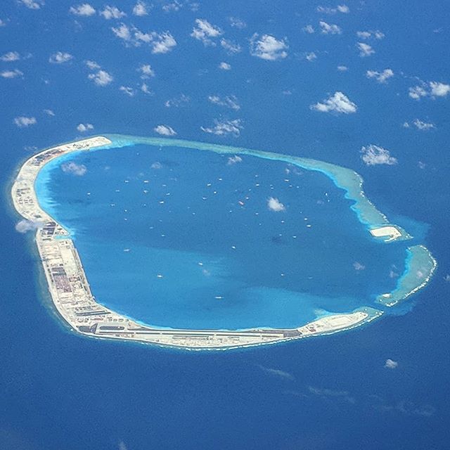
In a more recent example, 2016 FONOP carried out by the USS Decatur had the explicit goal of challenging China’s straight baseline around the Paracels as it did not sail within 12nm of a specific feature but rather zig-zagged through China’s declared internal waters. The intensification of U.S. efforts to challenge China’s maritime claims in the South China Sea, largely performed through FONOPs, coincided with both the South China Sea Arbitration ruling and the election of Donald Trump in 2016. While the Trump administration ‘upped the ante’ on opposing China’s claims, as seen in the language of Secretary Pompeo’s blunt 2020 policy statement, the Biden administration shows no signs of reversing back towards a more conciliatory posture. In a rare point of agreement across two very conflictive administrations, Secretary Antony Blinken reaffirmed Pompeo’s unambiguous statement in July 2021. His reaffirmation has been followed up by tangible policy as U.S.-led regional initiatives like the Quad have placed upholding international maritime law in the Indo-Pacific at center-stage.
What does this history reveal about contemporary U.S. policy, and what opportunities for change and continuity does it forecast going forward?
Despite the righteous language of its policy documents, it is clear that U.S. policy towards straight baselines in mid-ocean archipelagos continues to be affected by geopolitical concerns. Just as the Nixon administration weighed the Philippines’ perceptions of its response to China’s consolidation of the Paracels in 1974, the recent U.S. escalation of its opposition to China’s claims in the South China Sea came alongside a high-profile challenge lodged by Manila. Furthermore, it deployed its universalistic UNCLOS logic only after the collapse of its main rival in the USSR, and has since applied it selectively when it does not want to risk upsetting its strategic or ideological allies.
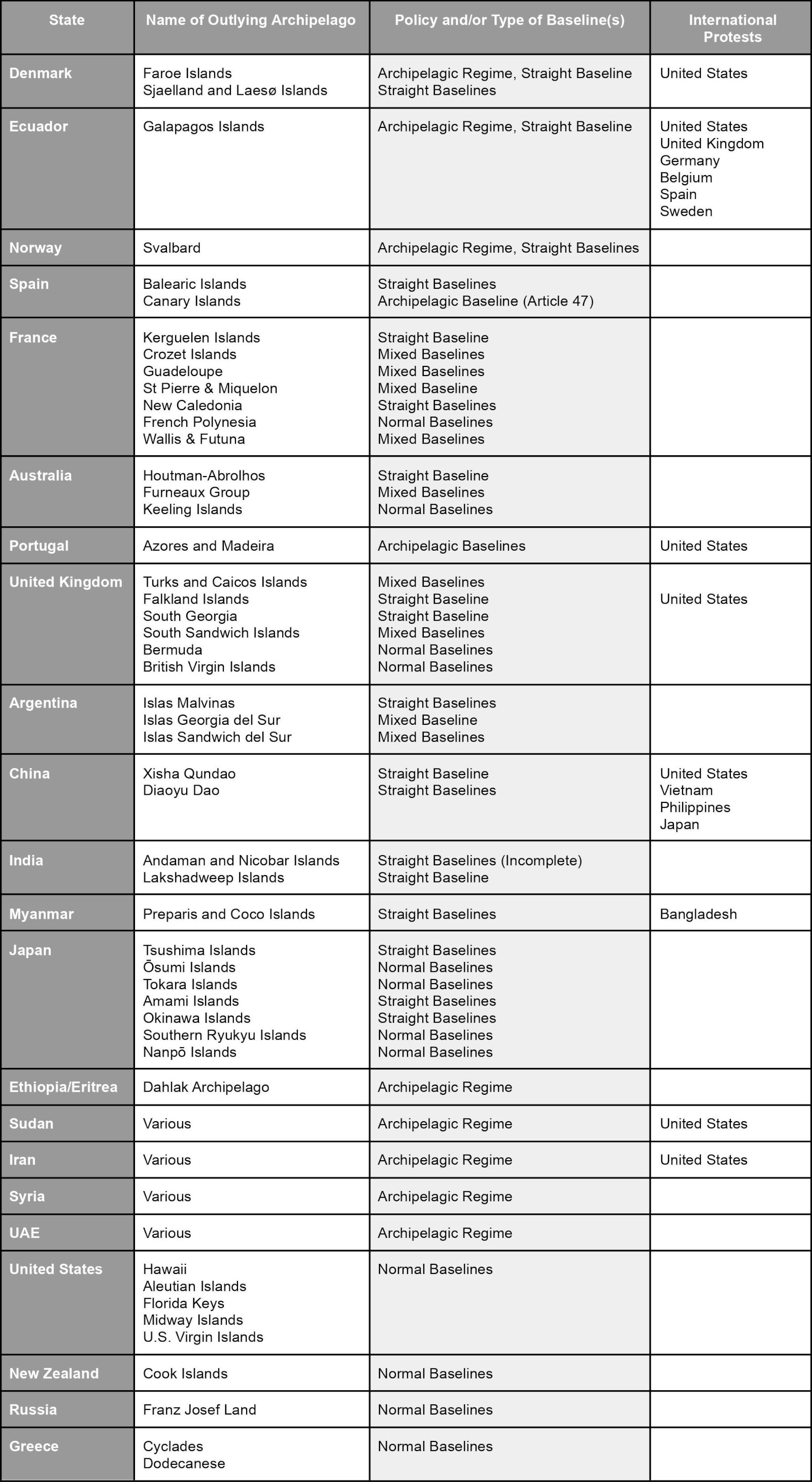
For example, the U.S. has not protested India’s straight baseline system in its mid-ocean Lakshadweep islands even though it exceeds the legal water-to-land ratio, baseline length, and archipelagic-state-only stipulations outlined in Article 47 of UNCLOS. The U.S. did recently conduct a FONOP in the vicinity of the Lakshadweep islands on April 7, 2021, but the operation took place 130nm off of the coast and was only intended to challenge India’s requirement for prior consent for military exercises within its EEZ. No physical incursion into India’s straight baseline was made and there is no mention of the straight baseline in the corresponding FONOP report. This is not the only case where the U.S. has disregarded the ‘archipelagic state’ condition in Article 47 for applying straight baselines to mid-ocean archipelagos. The U.S. has also either ignored or tolerated straight baselines around France’s subantarctic islands, Spain’s Canary islands, and Norway’s Svalbard archipelago. The U.S. has, however, publicly protested straight baselines declared by the UK in the Falklands, by Portugal in the Azores, and by Ecuador in the Galapagos, among other cases (while not exhaustive, for a global overview see Appendix A: Continental State Practice Towards Dependent Outlying Archipelagos). While the U.S. is by far the most prolific protestor of straight baselines which contravene UNCLOS, the picture seen upon zooming out is far from one of principled, universal, and apolitical criticism.
Across history, notable progress can be seen towards moving beyond issues of sovereignty in the South China Sea (though sovereignty in the Spratly Islands continues to be a thorny issue relative to the Paracels). Still, the recent resurgence of external interest in upholding written law—rather than taking state practice into consideration—suggests that this issue will not heal simply with time. It is unlikely that Washington will back down from a UNCLOS-framed policy in the South China Sea, and it is equally unlikely that the U.S. and its allies could coerce China by force into rolling back its straight baselines in the Paracel Islands, which Beijing currently controls de-facto in full. If the United States wishes to pressure China through other means, it will first have to ‘put its own house in order’—continental state practice of declaring straight baselines around mid-ocean archipelagos is not limited to the South China Sea, and the case of the Lakshadweep islands is particularly damaging to the legitimacy of the U.S. and Quad’s legal arguments.
Alternatively, China could take efforts to explicitly declare the Paracel Islands as an archipelago, entitled to archipelagic baselines under UNCLOS Article 47, and more closely harmonize its rhetoric with that of UNCLOS in an effort to garner support from other continental states who share an interest in preserving straight baselines in their own outlying archipelagos. China has already toned down its bespoke ‘nine-dash line’ claim and, to an extent, has begun to articulate its South China Sea claims in UNCLOS terms. Such a strategy could lead to more diffused international pressure on the U.S. to soften its legal purism and pose an opportunity for compromise in the otherwise intractable South China Sea dispute.
Regardless of what Washington or Beijing decide to do next, the Paracel Islands will continue to be yet another volatile point of contention in the already complex U.S.-China relationship and its importance—as well as its historic providence—should not be underestimated as international law continues to evolve.
Sources: CSIL, Kopela, Roach, Roach and Rothwell, and Su

South China Sea Arbitration at 10: State consent, jurisdiction and contested finality